Ireland is full of history. Whether it’s the uprising in Dublin, the tribes of Galway City, or vikings arriving onto our shores, there are stories of years gone by at every turn. However there’s a great deal you’ll miss if you simply stick to the towns, cities and sights along the tourist trail. Sometimes the only way to really see something is to get out of your car or off that tour bus and put your own two feet on the ground. It’s along the many hiking routes in the west of Ireland that you’ll see and experience things not found anywhere else on the Emerald Isle.
Lazy Beds
One day while hiking along the West of Ireland route in Connemara, I couldn’t help noticing that a certain field up ahead stood out from the rest. Its soil was oddly rumpled, for want of a better word, but this described it just perfectly. In a way, it appeared as if a baker had taken the soil as dough and folded it, creating an accordion effect of ripples and ridges. A local historian later enlightened me as to exactly what this feature was. It turns out that these are in fact “famine ridges,” and they appear all over the west of Ireland.
When planting potatoes, farmers created folds in the soil, which would later be flattened once more at harvest time. Such corduroy waves indicate that a field was actually never dug up when it came time to harvest, and this was due to recurring potato blight during the period of the great famine. A very dark part of Ireland’s history, the tragic famine period of the mid-19th century saw as one of its main causes precisely this potato blight. Hikers in Ireland who witness such famine ridges, also referred to as lazy beds, are viewing firsthand an area not tilled since its original owners either starved to death or emigrated (often to America) more than 150 years ago. Such an intimate glimpse back into the history that shaped Ireland can only take place on foot while trekking through the hills of Ireland.
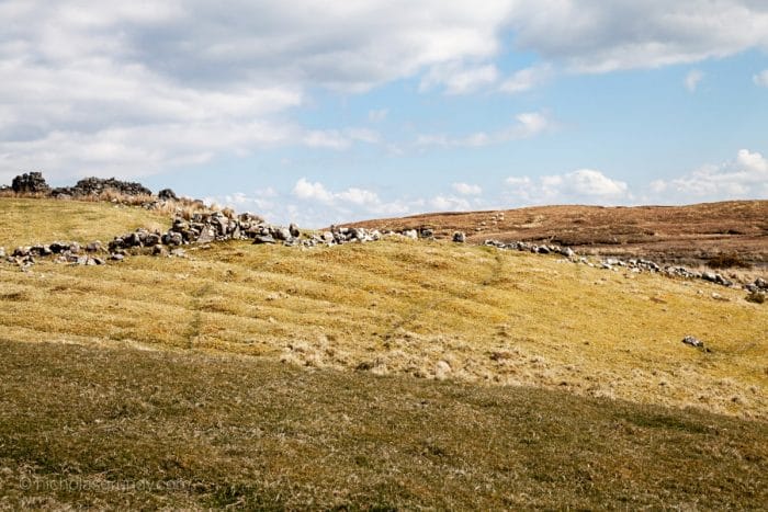
Famine Ridges in Connemara – Photo credit www.nicholasgrundy.com
Famine Roads
The famine period also left numerous tracks and pathways crossing the hills and valleys in the most obscure places. Today these roads seem inexplicable, as there’s nobody out there and very little sign of anyone ever having lived here and used them in the past. However there is an explanation for their existence. These roads are the result of an ill-fated attempt at rectifying the situation during the famine. The idea was to put the Irish peasantry to work in return for payment. Initially envisioned by Robert Peel’s government, the hope was that this would provide better infrastructure and access to the famine-stricken regions of the west of Ireland, while simultaneously providing paid employment to precisely those subsistence farmers who had recently lost their crops and had no other means of supporting themselves.
Instead the great masses flocking to these projects were often already too malnourished to work effectively, with many arriving to find that the harsh conditions and exposure to the elements were no better than back home. Adding insult to injury was the fact that these roads were often very poorly planned, providing next to no longterm benefit anyway, and traversing unrelenting and craggy terrain. Also referred to as green roads, these overgrown tracks now make up components of many of Ireland’s most popular walking routes, such as the Dingle Way, the West of Ireland route in Connemara and Mayo, and the Kerry Way. Perhaps the most obvious of these roads is located along the Burren Way, where the emerald hues of the track contrast starkly against the limestone landscape from which it was roughly hewn. Yet another way to literally feel the history of Ireland directly beneath your feet.
Famine Villages
Another sad relic of Ireland’s brutal famine period can be found in the multitude of famine villages. Again, these are found almost exclusively along the west coast. With their roofs long since returned to nature, all that’s left are clusters of four-sided, crumbling stone huts. Some of the most shocking examples are located on islands just a few miles off the coast, where every last resident either perished from starvation or was forced to flee to the mainland. It’s hard to believe that so many people once survived purely from a meagre diet of crops and presumably mutton on these miniscule and desolate islands.
Hikers along the West or Ireland route through Connemara and Mayo can experience firsthand what it must have been like to survive in such cramped conditions. Diverting briefly from the trail, and of course exercising caution, you can enter these ruined huts and get a glimpse into the history of rural Ireland. Believe it or not, it’s from here that many people across the globe, and especially in America, can directly trace back their ancestry. Keep an eye out for groups of stone ruins on your next hike in Ireland and don’t be afraid to take a closer look.
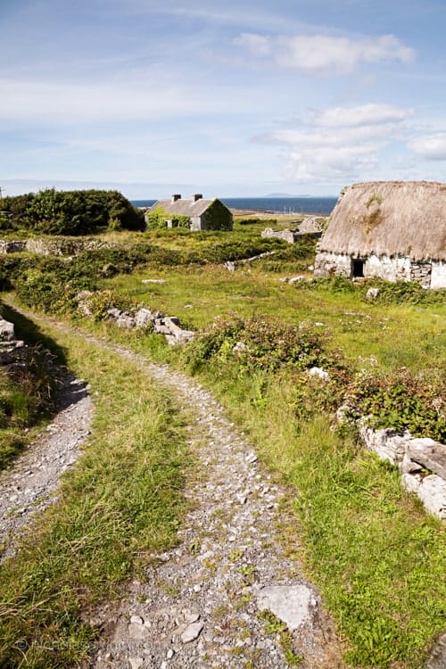
Abandoned cottages along the West of Ireland route in the Aran Islands – Photo credit www.nicholasgrundy.com
Ring Forts
Circular in nature – hence the name – ring forts can be found all over Ireland. While also appearing elsewhere in northern Europe, Ireland arguably has the highest concentration of them. The round fortifications vary in their size and construction. I’ve stood inside small earthen and stone enclosures in Connemara with diameters of only ten or twenty metres across, while the epic Dun Aonghasa ring fort in the Aran Islands, with its four-metre thick stone walls, boasts a diameter of 50 metres – and it’s only a semi-circle as the high cliffs over the Atlantic slice it right down the middle. Some of the forts are very simple in nature – mere earthen mounds providing rudimentary defence and now long overgrown with grass. The keen eye can spot these rounded edges while hiking in Ireland, often with a sheep perched on top, munching away at the delicious foliage which has now taken over.
Other ring forts are quite complex affairs, featuring multi-tiered ramparts connected by stone staircases, as well as internal chambers and tunnels both within the walls and under the ground. Some even incorporated multi-layered defences outside of the walls consisting of long, jagged stones placed at various vertical angles and clustered together to create impenetrable barriers. This would help funnel the attacking troops into certain areas while also slowing their movement, a tactic very similar to that exhibited by the dragon’s teeth and Spanish horse tank traps used in World War 2.
While estimates vary, historians and archaeologists agree that somewhere between forty and fifty thousand ring forts once existed in Ireland, with approximately 80% still identifiable today. Quite an accomplishment for such a small island! While many were unknowingly dismantled by farmers wishing to create walls for their fields, hundreds are still being discovered today thanks to modern advances in satellite and aerial imagery. In the summer of 2018 Ireland saw an unusually long period of hot and dry weather. The near drought-like conditions in fields in County Meath in particular allowed for drone photographs and aerial videos to pick up on the outlines of ancient circular forts hidden beneath numerous fields. So, when you’re next out hiking around Ireland, keep an eye out for the markers on your map denoting nearby ring forts, and see if you can spot them or hike over to them for a closer inspection.
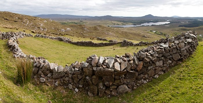
Ring Fort near the West of Ireland Route in Connemara – Photo credit www.nicholasgrundy.com
Norman Towers
During the Norman period, Ireland saw an unprecedented level of castle building around the country, with each well-off family, clan, and nobleman requiring his own fortification. The older ring forts mentioned previously were superseded by a similarly high number of small castle towers from the 1200s onwards. Once again this made Ireland one of the most densely castellated countries on earth, with either a ring fort or Norman tower in every couple of square kilometres across the entire country, on average.
A standard castle as we know it today comprises a central keep, four walls, and four turrets at each corner of these walls. The Norman castle towers dotting the Irish landscape instead were standalone towers, square in shape and resembling a flat-edged turret. With no outer wall, the towers simply provided immediate defence for their owners. Instead of functioning as actual military-oriented castles, guard posts, or lookout towers, they were used predominantly as a defendable home for the well-to-do owners, hence their referral to as tower houses. Often four stories high or taller, they can be readily spotted in the distance and easily approached for a closer look. While many are in ruins alongside the hiking trails of Ireland, hundreds have been lovingly restored and used as homes, venues and hotels today. My wife and I were even married in one not too far outside Galway City!
Stone Walls
Ah yes, the ubiquitous Irish stone wall. You cannot really have a list about Ireland or Irish history without mentioning our famed stone walls at least once. Especially when we’re dealing with the west coast where they are seemingly everywhere. The well-known band “The Saw Doctors” even mentions them in their song “N17.”
Although our view of them is often quite romantic, there’s unfortunately a dark side to some of these walls as well. Yes, we’re back to the famine again. Just like with the famine roads, many of these walls were built by the poor such that they could work for sustenance instead of simply being looked after by charities. Once again the result was a series of unnecessary walls criss-crossing the west coast. This explains why, when hiking around Ireland, many of the stone walls around you don’t seem to make any sense, launching off in all directions and directly up steep hillsides. Fortunately many of them did and still do serve a purpose, separating farmers’ fields while having aided in clearing up the far too rocky pastures. Another example of how the famine changed the landscape of Ireland forever.
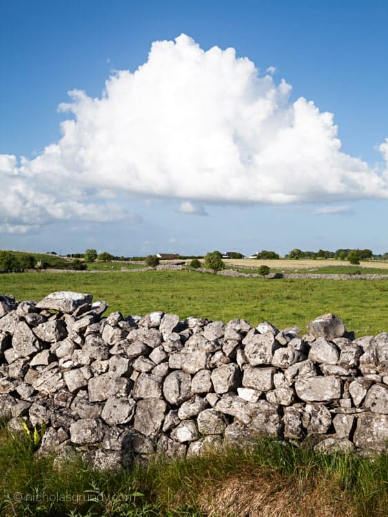
Stone wall along the West of Ireland route in Connemara – Photo credit www.nicholasgrundy.com
Connemara Ponies
This peculiar breed of pony is a living part of Ireland’s history. Before I first visited the Connemara region (roughly the western third of County Galway), I’d always viewed ponies as miniature horses most commonly found at petting zoos and children’s circuses. However the Connemara Pony is quite a contrary creature and would take great offence at being compared to something as miniscule as a Shetland Pony. The majestic breed is too large to be classified as a true pony in my own opinion. Should you be fortunate enough to have the opportunity to take a ride through the hills atop one of these beautiful animals, you’ll soon realise they are in fact still ponies at heart. Although a tough and robust breed, their friendly disposition and obedience make them perfect for riders of all ages and abilities. Compared to horses I’ve ridden elsewhere, the Connemara Pony is very calm and well-mannered.
Hikers in the west of Ireland, especially in Connemara, will often find this particular variety of pony grazing peacefully along the steep, windswept slopes of western County Galway. Their brawn and athleticism are quite impressive to say the least. Not only do Connemara ponies compete in show jumping and dressage, but they can even be found taking part in endurance riding contests, further challenging the traditional view of what makes a pony and what makes a horse.
Historians differ as to precisely how the Connemara Pony’s genealogy was first influenced. Many do agree, however, that they hail from a mix of some of the toughest breeds the world has ever seen. One line of thinking is that the Vikings introduced Scandinavian ponies, initially shaping their ancestry, while others contend that their strength harks back to the now-extinct Irish Hobby. There is also evidence to suggest that Spanish Andalusians arrived by sea after the Spanish Armada was defeated in 1588. Apparently we’ve even had stocky Arabians enter the mix here in the west of Ireland. Regardless of their historical bloodline, we can safely say that these beauties developed their resilience and agility across the unrelenting landscapes of Connemara.
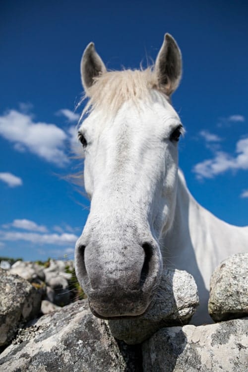
Connemara Pony along the West of Ireland route – Photo credit www.nicholasgrundy.com
So, keep an eye out for these gleaming white ponies on your next hike in Connemara and also while further afield elsewhere on a hike in the west of Ireland. And don’t forget to pay attention to your map and check out some of the many other pieces of Irish history while out and about.
We hope that you enjoyed this guide to 7 Pieces of Irish History You’ll Only See Hiking in Ireland. If you’ve any questions about taking an Ireland hiking tour, just get in touch.


